Photo 16 (508)
A photo of Kris taken by a stream.
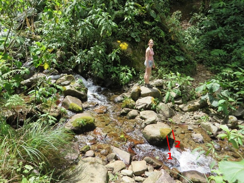
Photo 16-1
We have the following data needed to calculate the time of taking photo 16:
For segment 1:
L = 11.0 pixels
H = 53.0 pixels
date = 2014-04-01 (April 1st 2014)
latitude = 8.843432
longitude = -82.424660
time zone = -5
DST = 0 (Daylight Saving Time, there is no DST in Panama)
The results obtained by means of method 1 (here is a description of method 1):
elevation = 78.27 deg. (cell B55 in the spreadsheet)
local time 1 = 13:17:42
azimuth 1 = 250.03 deg.
local time 2 = 11:49:19
azimuth 2 = 109.97 deg.
For segment 2:
L = 8.0 pixels
H = 33.0 pixels
date = 2014-04-01 (April 1st 2014)
latitude = 8.843432
longitude = -82.424660
time zone = -5
DST = 0 (Daylight Saving Time, there is no DST in Panama)
The results obtained by means of method 1 (here is a description of method 1):
elevation = 76.37 deg. (cell B55 in the spreadsheet)
local time 1 = 13:25:49
azimuth 1 = 253.15 deg.
local time 2 = 11:41:12
azimuth 2 = 106.85 deg.
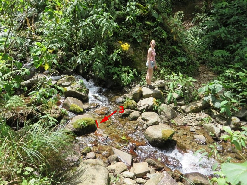
Photo 16-2
For segment 3:
L = 8.0 pixels
H = 26.0 pixels
date = 2014-04-01 (April 1st 2014)
latitude = 8.843432
longitude = -82.424660
time zone = -5
DST = 0 (Daylight Saving Time, there is no DST in Panama)
The results obtained by means of method 1 (here is a description of method 1):
elevation = 72.90 deg. (cell B55 in the spreadsheet)
local time 1 = 13:40:22
azimuth 1 = 257.08 deg.
local time 2 = 11:26:39
azimuth 2 = 102.92 deg.
In search of quebrada 1 part 1
I made a map trying to find the place where photos 507 and 508 were taken.
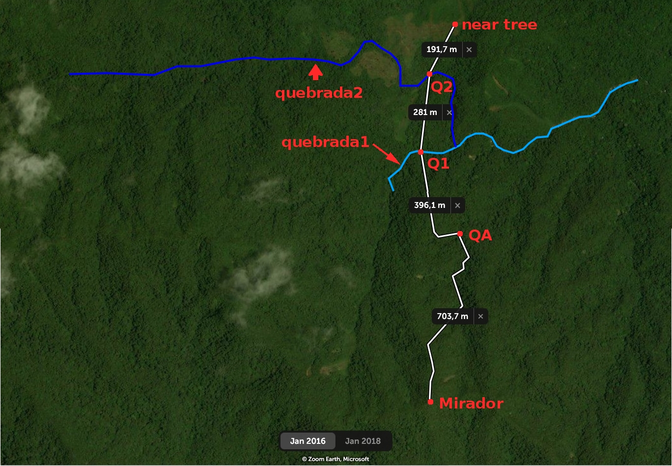
Photo 16-3
Labels on the map:
QA - the position of quebrada 1 according to the ArcGIS map. See the photo showing the position.
Q1 - the crossing across quebrada 1 according to the coordinates on this map, the place where photos 507 and 508 were taken.
Q2 - the crossing across quebrada 2, the place visited by Kris' parents (see the film at 13:20 showing the stream crossing).
near tree - another place visited by Kris' parents (see the film at 16:01). That is a place after quebrada 2. The distinctive element of the place is the tree that you can see in the film (at 17:43).
The above map is made on the basis of the following assumptions:
1. The coordinates of the crossing across quebrada 1 are taken from this map:
Photo 16-4
These are the coordinates: 8° 50' 34.8'' N 82° 25' 26.4'' W (8.843,-82.424). Quebrada 1 is the stream visible on the satellite map:
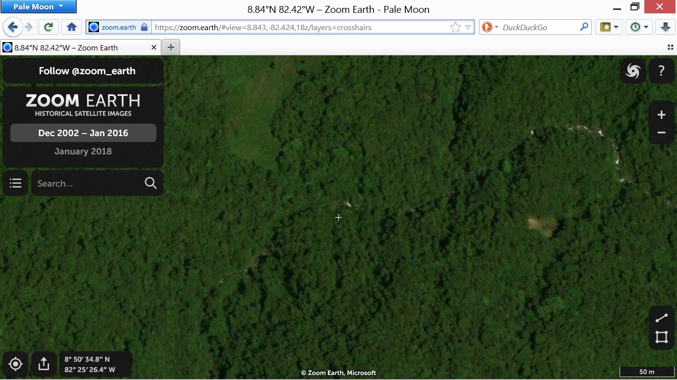
Photo 16-5
The small cross indicates the stream crossing. The cross is near the stream crossing. This is caused by some inaccuracy of the coordinates. The stream itself (quebrada 1) was led according to the map in photo 16-5. It is only a fragment of quebrada 1 because none of the maps which I found shows the quebrada.
2. Quebrada 2 was led according to this map:
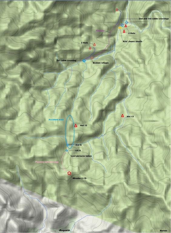
Photo 16-6
Quebrada 2 is the stream that is led from left to the blue ellipse denoted "Accident area". I only changed the last segment of the stream so that the stream would not cross a meadow. I made it according to the following satellite map:
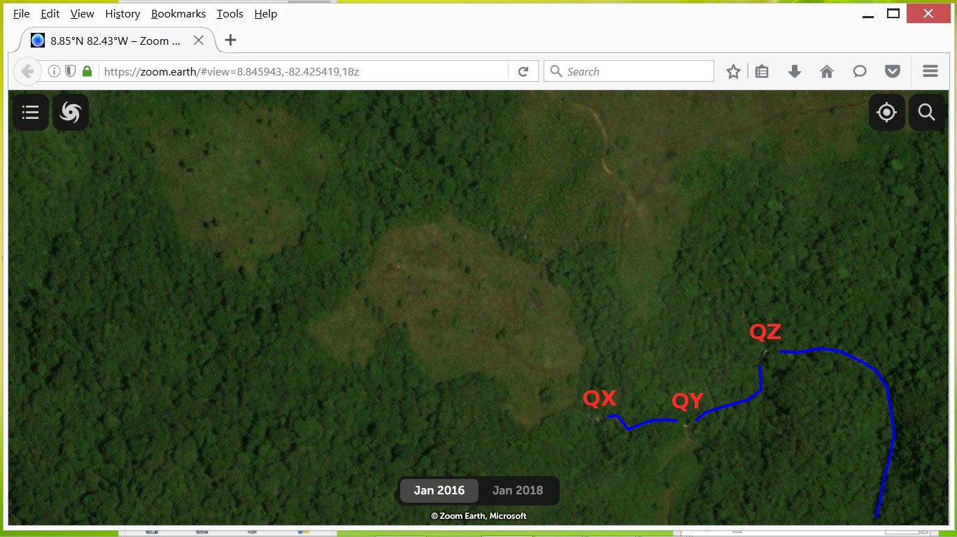
Photo 16-7
You can see three candidates for the stream crossing on the map: QX, QY, QZ. I chose QZ as the place Q2 on the map in photo 16-3.
3. The path from the Mirador to quebrada 1 was led according to this map:
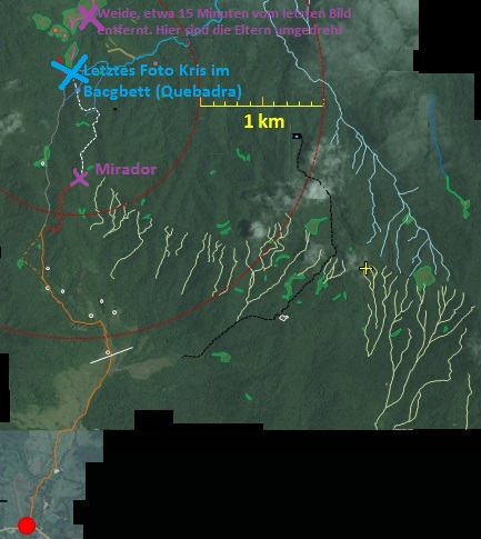
Photo 16-8
4. The position of the 'near tree' point was set according to the map in photo 16-8. That is the point denoted by the violet cross near the sign "Weide, etwa 15 Minuten vom letzten Bild entfernt. Hier sind die Eltern umgegreht." ("A pasture, about 15 minutes from the last picture. Here the parents turned back." - a translation based on the context.reverso.net website) Both pieces of information in the sign are incorrect: the place is not 15 minutes from quebrada 1, but 35 minutes; Kris' parents turned back from a place an hour and a half from the place where the last photo was taken (they did not turn back from the place near the tree). Despite those errors I assumed that the place where Kris' parents stopped is marked correctly.
Photo 16-3 also shows some distances between places denoted by red dots. These are times taken from the film illustrating distances between some places beyond the Mirador:
from the Mirador to Q1 - 45 minutes (about 1100 m, see the map in photo 16-3);
from Q1 to Q2 - 20 minutes (281 m);
from Q1 to the 'near tree' point - 35 minutes (473 m).
from the Mirador to the 'near tree' point - 1 hour 20 minutes (1854 m).
A disadvantage of the above distances is that the distance of 1100 m corresponds to the time of 45 minutes, and the more than twice smaller distance (473 m) corresponds to the time not much shorter (35 minutes). That can be caused by the fact that the real paths after quebrada 1 are not straight lines like I drew.
The whole time from the Mirador to the 'near tree' point is comparable to the time in this film. The men in the film went the same distance in an hour and a half.
Compare the above times with the information from the following website:
"Thirty minutes or so would have got them to the first quebrada or creek, There
is a second quebrada another ten minutes along the path, both of these creeks
join a little further down and they make up the headwaters of the Rio Culebra."
So according to the information these are the following times:
from the Mirador to quebrada 1 - about 30 minutes;
from quebrada 1 to quebrada 2 - 10 minutes.
In search of quebrada 1 part 2
Under the article, I found different coordinates of quebrada 1. These are the coordinates of some places from a comment under the article:
- quebrada 1: 8.8426814, -82.4247221,
- quebrada 2: 8.8452174, -82.4241608,
- point "near tree" (a path near a pasture): 8.8471302, -82.4248081,
- point "almost at the top of the next mountain": 8.8551513, -82.4258406. (That is the place where Kris' parents turned back after an hour and a half of the hike from quebrada 1. See 18:50 in the film.)
The above coordinates of quebrada 1 point almost at the same place as the coordinates of waypoint 03 which I found on the website describing a hike from the start of the El Pianista trail to Bocas del Toro. These are the coordinates of waypoint 03:
8.842666667,-82.424861111.
Here is the link to the kmz file which contains the coordinates. It is possible to convert a kmz file to a text file, for example here.
The map below shows the positions of the above mentioned coordinates:
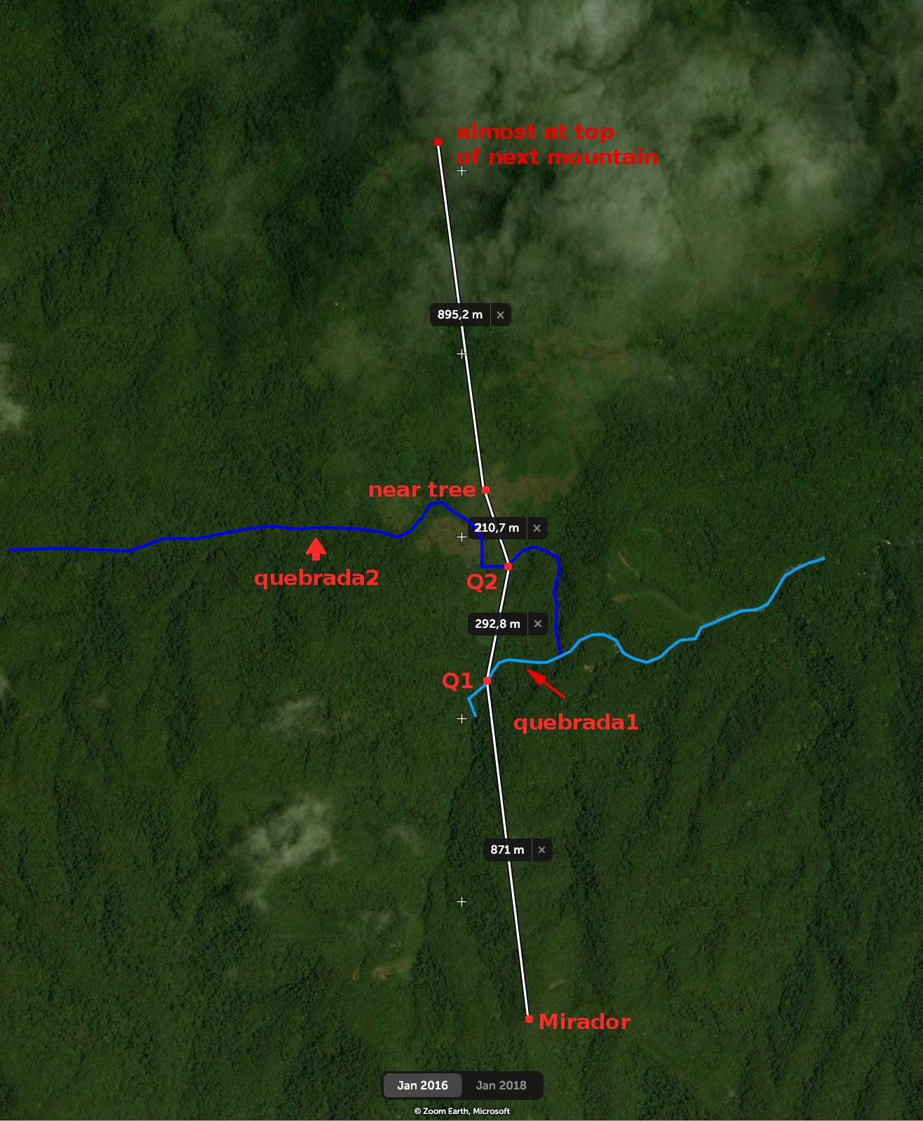
Photo 16-9
I also found a topographic map where both quebradas are shown:
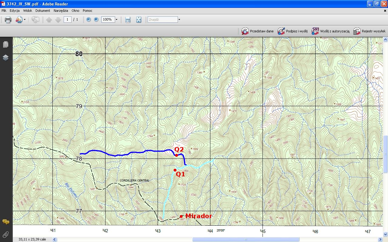
Photo 16-10
That is only a fragment of a larger map. You can download the map in the form of a pdf file from here. You need to find the proper rectangle. That is a rectangle above the rectangle containing the sign "Boquete". When you click on the rectangle, a window appears with some information. The "More info" link is used to download the pdf file. On the above map, I marked both quebradas with various shades of blue. Q1 and Q2 denote the stream crossings.
In search of quebrada 1 part 3
I found a map of the trail beyond the Mirador on the wikiloc website. There are over a dozen photos on the website. There is a photo of a stream crossing which resembles the stream crossing that RomainC reached in the film. Here is a comparison of photos of the stream crossing:
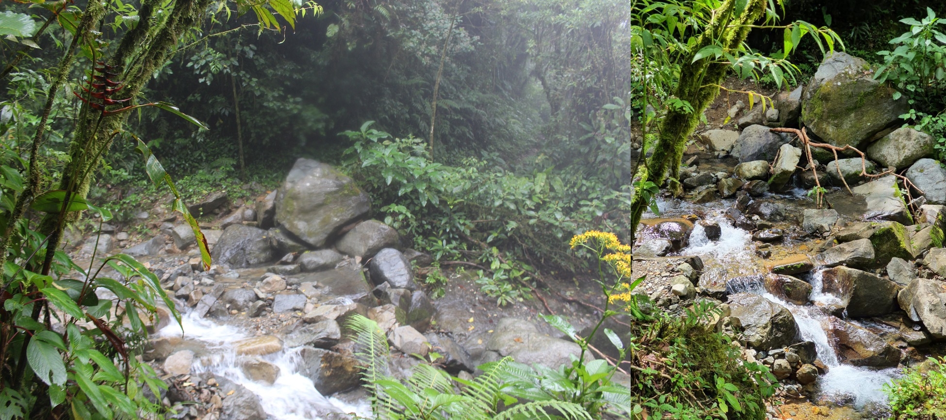
Photo 16-11
The left part in the above photo is a photo from the CamilleG blog. The right part is a photo from the wikiloc website. It is good to start the comparison of the views with the largest stone. RomainC is a Frenchman who has been investigating the case of Kris and Lisanne for some time. He hiked the El Pianista trail and the trail beyond the Mirador in August 2019.
Here is a map of the trail beyond the Mirador from the wikiloc website.
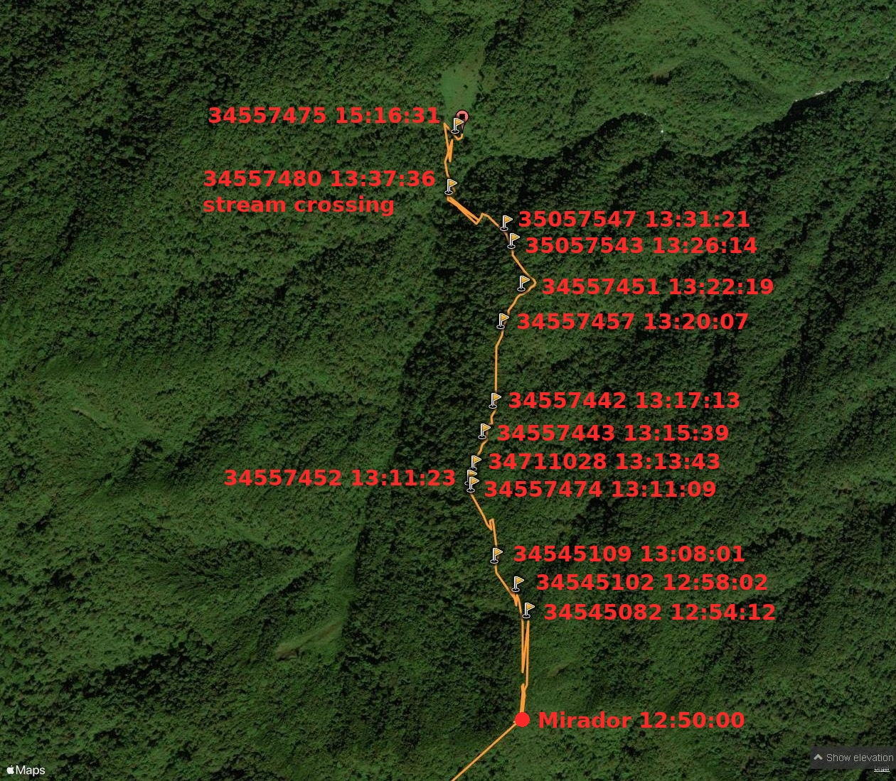
Photo 16-12
There are numbers of photos from the wikiloc website on the map. There are EXIF times of photos as well. The time at the sign "Mirador" is an estimated time. The bottom number in photo 16-12 (34545082) is a number of the photo that was taken in the vicinity of the place visible in the film at 8:51. (See the photo on the wikiloc website taken at the place). That is a kind of fork in the path. The return time from the place to the Mirador was 5:17. I assumed that the time of the way down took 4 minutes.
Because the stream crossing in photo 16-11 does not resemble the stream crossing in photo 508, the next candidate for the stream crossing is the crossing shown in photo 16-3. After my recent discovery, the situation looks like this:
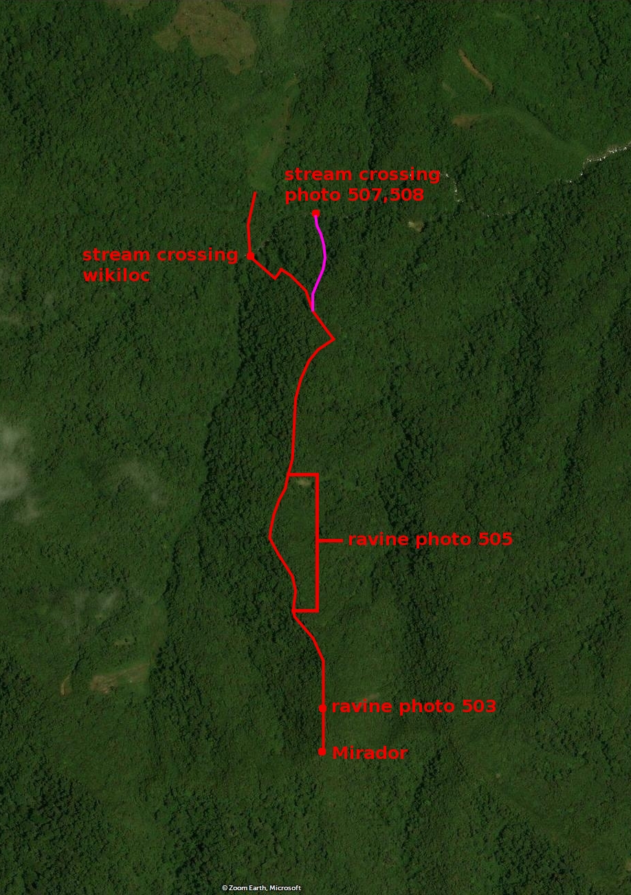
Photo 16-13
The red path denotes the path in photo 16-12. The pink path is a possible path to the stream crossing denoted Q1 in photo 16-3.
In search of quebrada 1 part 4
The new list of EXIF times appeared, so the situation looks like this:
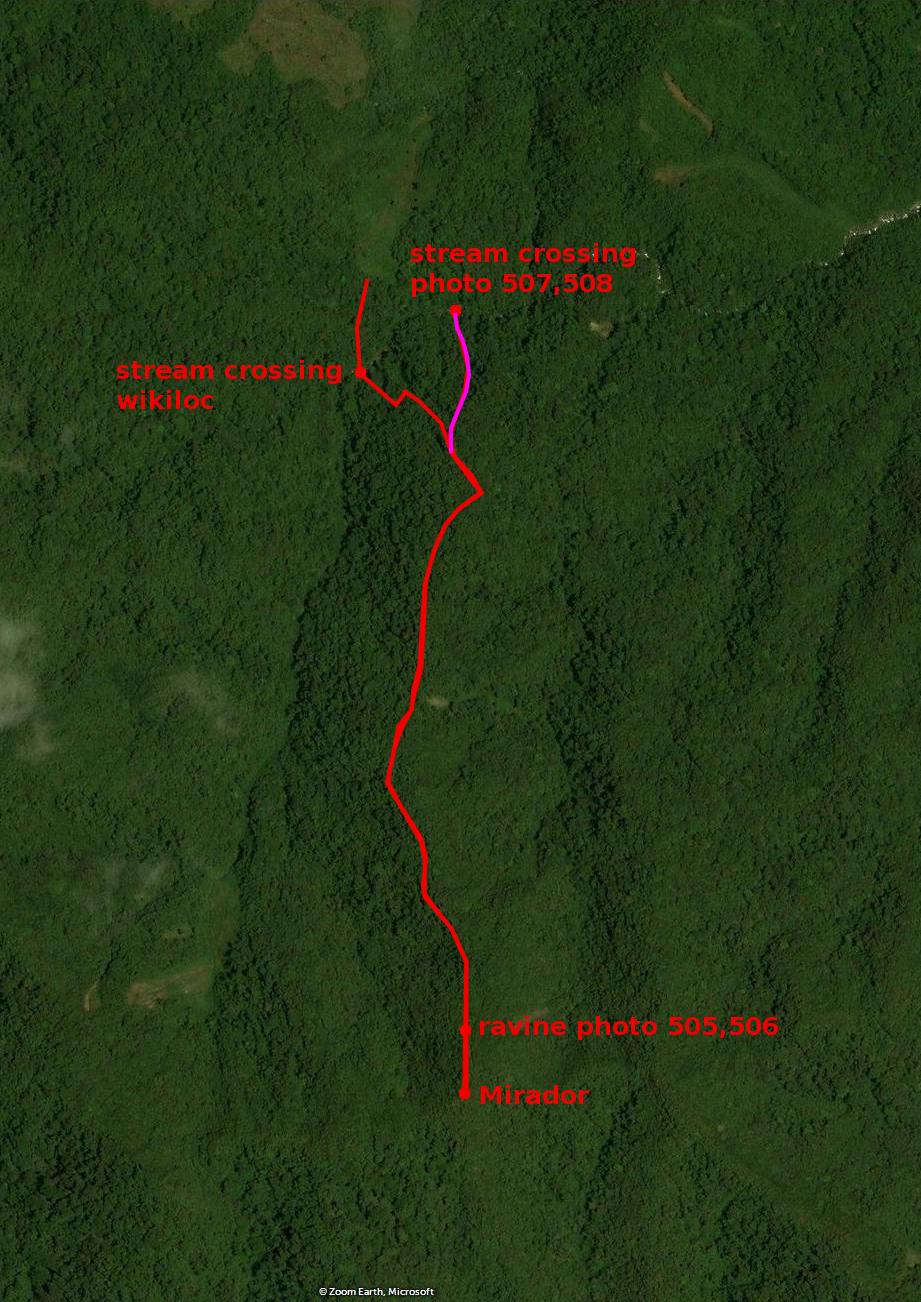
Photo 16-14
It seems that the photo of a ravine (506) and photo 505 were taken at the same place or at places very close to each other.